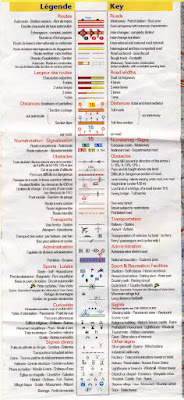
 Since I'm relatively new to the area, and the weather is getting colder, I probably won't be going hundreds of miles in one day. Thus, I opted for Michelin #322, a single-sided map covering two départements (Deux-Sèvres and Vienne) within the Poitou-Charentes region with a scale of 1 cm to 1.5 km (or 1:150,000).
If you are going to be using a particular map a lot, perhaps for touring, I would suggest cutting it up into pieces that fit into whatever map-holder you will be using (thus the choice of a singled-sided map). I also numbered my map pieces so I can find the adjacent map sections. It is much easier to exchange two small pieces of paper than to pull out an entire map and refold it so the area of interest is displayed.

Besides all the pretty colors, the maps are packed with useful information. The most mentioned aspect of these maps in relation to cycling is the green line. I won't attempt to outdo the linked post in terms of rhetorical elegance, but I don't agree that the green line is always the Holy Grail of cycling (at least around here, maybe the Alps are different).
For the uninitiated, the green line represents a scenic route, which can mean several different things depending on the terrain: a winding road through, into, or out of a valley, or as is more often the case in Poitou-Charentes, simply a straight, flat road through a forest. On my rides, I try and seek out the varied terrain and beautiful views of valleys in the area (the Vienne River valley is especially rural and hilly), but I'm less interested in a straight, flat road, even if it is through a forest.
One other consideration when choosing a route is the amount of automobile traffic. The roads in red are part of the high-traffic national road system. Recently, we read an article in the local paper about how dangerous these roads can be. One particular local road (N147, shown in the second picture of this post) has resulted in nineteen auto-related deaths in the past three years. The roads in yellow are for more local traffic. When leaving Poitiers, I stick to the thick white roads. They are used enough to be well-paved and well-marked, but traffic is limited to people coming and going from nearby small towns. Once you are 15-20 km outside of Poitiers, the yellow roads become low-traffic, and are often very well maintained.

Of course, as a bonus, Michelin maps denote all kinds of landmarks that are worth checking out, from chateaus, abbeys, and churches to sites of ancient battles and Roman ruins. The sites are also conveniently graded with a series of stars (0-3 stars) telling whether they are merely worth visiting if you happen to be nearby, or are worth a visit in their own right.

2 comments:
I like this post. Also, just wanted to reply so you know someone is reading this blog. Thanks
heh. I think it's just you and our parents reading... on the other hand, this makes writing audience-appropriate material just that much easier.
Post a Comment